|
|
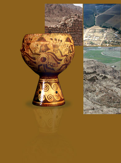
San José de Moro (SJM) is a small community located on the right bank of the Chamán river in the Jequetepeque Valley (Pacanga District, Chepén Province, Department of La Libertad), which was one of the most important cemetery sites and regional ceremonial centers of the Moche society and subsequent cultures.
The site is a sandy plain of approximately 10 ha, sitting at 13 m above sea level on what is currently cropland. Surrounding the site are fourteen artificial hillocks, many of which are ruins of pre-Hispanic buildings whose original form it is not possible to define with exactitude due to erosion and looting suffered over the course of hundreds of years. Among the hillocks of major importance we have Huaca Cuadrángulo, Huaca Suroeste, Huaca La Capilla, Huaca Alta, and Huaca Chodoff.
In the surrounding region of San José de Moro, in the Jequetepeque Valley, we also find a series of archaeological sites of particular note:
- Cerro Chepén, a Late Moche site located 3 km to the south of SJM. The site was well fortified and contains numerous housing units, which were possibly quarters for people who would later be interred at SJM. The walled area covers approximately 10 ha and includes ceremonial grounds and residences for the elite.
- San Ildefonso, a Late Moche site located in the desertified zone adjacent to the mouth of the Chamán River. It is believed to be one of the region’s most important local political centers. The site includes three lines of defensive walls as well as ceremonial areas, residential units, and storage areas.
- El Algarrobal de Moro, located to the east of SJM (across the Panamericana Highway), an administrative center during the Chimú and Chimú-Inca periods where courtyards, rectangular plazas, and various architectural structures have been discovered.
- Portachuelo de Charcape, a Late Moche site located in the lower part of the valley, on the left bank of the Chamán River. The site is a wide level plain flanked by a string of mountains from which it is possible to observe 3 structures with courtyards, ramps, and benches. According to studies performed at the site, it served a combination of administrative, residential, and ceremonial functions.
- Cerro Catalina or Ciudadela Cerro Pampa de Faclo, located on the northern bank of the Jequetepeque River. It consists of a walled village of grand dimensions containing a series of structures. Inside two defensive walls are situated communal and public spaces. The housing structures are located on the lower and middle levels of the hill, while the public works areas are found at the top. In the residential areas we observe various subdivided rooms, while in the upper areas we find gravelly terraces.
The fluvial ecosystem of the Jequetepeque Valley is formed by two rivers: the Jequetepeque River and the Loco or Chamán River, which have distinct basins and deltas. During the explorations performed by the SJMAP, the valley’s pre-Hispanic irrigation systems were documented with fine precision, taking note of their original configuration and growth over time. In this way, a detailed study was made of all aspects related to the control of natural resources necessary for the creation of agricultural fields, as well as of the appearance and abandonment of archaeological sites during the different periods of the valley’s occupation.
read more ::

|
|